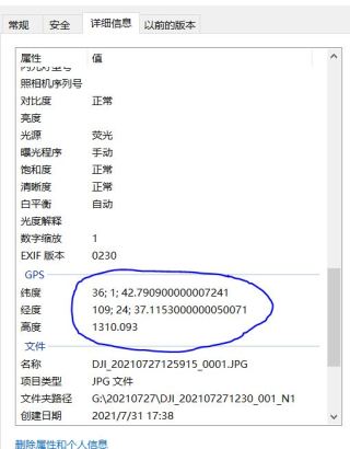
python使用exifread读取图片GPS信息为分数,我需要获取完整数据
问题描述:
我使用exifread模块读取图片的GPS信息,但由于GPS坐标的精度太高(如图),读取出来的坐标小数点后以分数显示,我需要完整的数据。另外请教使用Image读取GPS数据的方法(photo.info没用明白)
import os
import os.path
import exifread
import csv

workspace = r'G:\20210727'  # 此处输入飞行当天文件夹路径
PhotoName = []  # 图片名
PhotosPath = []  # 图片路径列表
Bs = []
Ls = []
Hs = []
i = 0  # 图片总数


def creation_pos(path):     # 以架次文件名创建POS文件
    for root, dirs, flies in os.walk(path):
        for FileName in dirs:
            pos_name = os.path.join(path, FileName)
            file = open(pos_name + '.csv', 'w')  # 创建以架次名命名的csv文件
            file.close()


def get_path(path):  # 递归获取.JPG文件路径,并写入PhotosPath列表
    global PhotosPath, i
    parents = os.listdir(path)
    for parent in parents:
        f = os.path.join(path, parent)
        if os.path.isdir(f):
            get_path(f)
        else:
            if f.endswith('.JPG'):
                PhotosPath.append(f)  # 将图片路径添加至图片列表
                i += 1
                print(i)


get_path(workspace)
for Photo1 in PhotosPath:
    name = os.path.basename(Photo1)
    PhotoName .append(name)
    Photo = open(Photo1, 'rb')
    Photo2 = exifread.process_file(Photo)
    Bs.append(Photo2['GPS GPSLatitude'])
    Ls.append(Photo2['GPS GPSLongitude'])
    Hs.append(Photo2['GPS GPSAltitude'])
    print(Ls)
https://lexsaints.blog.csdn.net/article/details/118467097 https://lexsaints.blog.csdn.net/article/details/118467097
https://lexsaints.blog.csdn.net/article/details/116568510 https://lexsaints.blog.csdn.net/article/details/116568510
里面有详细读取流程,包括经纬度分数转成百分制小数的方法。有问题,可以联系我
请立即采纳谢谢!
import exifread
import re

def FindGPSTime(filePath):
    GPS={}
    Data=""
    f=open(filePath,'rb')
    tags=exifread.process_file(f)

    for tag,value in tags.items():
        if re.match('GPS GPSLatitudeRef',tag):
            GPS['GPSLatitudeRef(纬度标识)']=str(value)
        elif re.match('GPS GPSLongitudeRef',tag):
            GPS['GPSLongitudeRef(经度标识)']=str(value)
        elif re.match('GPS GPSAltitudeRef',tag):
            GPS['GPSAltitudeRef(高度标识)']=str(value)
        elif re.match('GPS GPSLatitude',tag):
            try:
                match_result=re.match('\[(\w*), (\w*), (\w.*)/(\w.*)\]',str(value)).groups()   #匹配临近的字符
                GPS['GPSLatitude(纬度)']=int(match_result[0]),int(match_result[1]),int(match_result[2])/int(match_result[3])
            except:
                GPS['GPSLatitude(纬度)']=str(value)
        elif re.match('GPS GPSLongitude',tag):
            try:
                match_result=re.match('\[(\w*), (\w*), (\w.*)/(\w.*)\]',str(value)).groups()
                GPS['GPSLongitude(经度)']=[int(match_result[0]),int(match_result[1]),int(match_result[2])/int(match_result[3])]
            except:
                GPS['GPSLongitude(经度)']=str(value)
        elif re.match('GPS GPSAltitude',tag):
            GPS['GPSAltitude(高度)']=str(value)
        elif re.match('Image DateTime',tag):
            Data=str(value)
    return {'GPS 信息':GPS,'时间信息':Data}

if __name__=='__main__':
    print(FindGPSTime("照片.jpg"))

