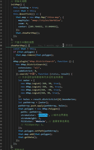
高德地图怎么才能只渲染局部地图?
这个只用遮罩覆盖中国以外的地图,我想要的是中国以外的就没有,不是颜色覆盖。
<!doctype html>
<html>
<head>
    <meta charset="utf-8">
    <meta http-equiv="X-UA-Compatible" content="IE=edge">
    <meta name="viewport" content="initial-scale=1.0, user-scalable=no, width=device-width">
    <title>地图遮罩</title>
    <style>
    html,
    body,
    #container {
        margin:0;
        height: 100%;
    }
    </style>
</head>
<body>
<div id="container"></div>
<script src="https://webapi.amap.com/maps?v=1.4.15&key=你的key&plugin=AMap.DistrictSearch"></script>
<script>
    var map = new AMap.Map('container', {
        zoom:12.6,
        center:[116.364495,39.930694],
          pitch: 0,
        viewMode: '3D',
        //设置地图背景图
        mapStyle:'amap://styles/blue'

    });
       //map.setZoom(12.2); //设置地图层级
    new AMap.DistrictSearch({
        extensions:'all',
        subdistrict:0
    }).search('中国',function(status,result){
        // 外多边形坐标数组和内多边形坐标数组
        var outer = [
            new AMap.LngLat(-360,90,true),
            new AMap.LngLat(-360,-90,true),
            new AMap.LngLat(360,-90,true),
            new AMap.LngLat(360,90,true),
        ];
        var holes = result.districtList[0].boundaries

        var pathArray = [
            outer
        ];
        pathArray.push.apply(pathArray,holes)
        var polygon = new AMap.Polygon( {
            pathL:pathArray,
            //线条颜色,使用16进制颜色代码赋值。默认值为#006600
            strokeColor: 'rgb(20,164,173)',
            strokeWeight: 4,
            //轮廓线透明度,取值范围[0,1],0表示完全透明,1表示不透明。默认为0.9
            strokeOpacity:0.5,
            //多边形填充颜色,使用16进制颜色代码赋值,如:#FFAA00
            fillColor: 'rgba(0,0,0)',
            //多边形填充透明度,取值范围[0,1],0表示完全透明,1表示不透明。默认为0.9
            fillOpacity: 1,
            //轮廓线样式,实线:solid,虚线:dashed
            strokeStyle:'dashed',
            /*勾勒形状轮廓的虚线和间隙的样式,此属性在strokeStyle 为dashed 时有效, 此属性在
              ie9+浏览器有效 取值:
              实线:[0,0,0]
              虚线:[10,10] ,[10,10] 表示10个像素的实线和10个像素的空白(如此反复)组成的虚线
              点画线:[10,2,10], [10,2,10] 表示10个像素的实线和2个像素的空白 + 10个像素的实
              线和10个像素的空白 (如此反复)组成的虚线*/
            strokeDasharray:[10,2,10]
        });
        polygon.setPath(pathArray);
        map.add(polygon);
       /*   var polyline = new AMap.Polyline({
        strokeColor: '#3366FF',   // 线颜色
        strokeOpacity: 1,         // 线透明度
        strokeWeight: 2,          // 线宽
        strokeStyle: 'solid',     // 线样式
        strokeDasharray: [10, 5], // 补充线样式
        geodesic: false            // 绘制大地线
    });
       polyline.setPath(pathArray);
       map.add(polyline);*/
    })
</script>
</body>
</html>
现在这个样子很丑:


源码:
<template>
  <div class="amap">
    <div
      v-loading="loading"
      element-loading-text="地图加载中"
      element-loading-spinner="el-icon-loading"
      element-loading-background="rgba(0, 0, 0, .9)"
      id="china-map"
    ></div>
    <keep-alive>
      <Detail
        :show="equipmentModel"
        :data="equipmentModelData"
        @close="closeModel"
      />
    </keep-alive>
  </div>
</template>

<script>
/**
 * @author        全易
 * @time          2020-12-30 16:28:02  星期三
 * @description   电站覆盖图
 */
import api from "@/service/api/overviews";
import Detail from "./detail";

export default {
  name: "cover-map",
  components: {
    Detail,
  },
  data() {
    return {
      loading: false,
      map: null,
      params: {
        loginName: this.$store.state.userInfo.loginName,
        stationNo: "",
      },
      polygon: "",
      equipmentModel: false,
      equipmentModelData: {},
    };
  },
  mounted() {
    this.initMap();
  },
  methods: {
    // 初始化地图
    initMap() {
      this.loading = true;
      const that = this;
      this.$nextTick(() => {
        that.map = new AMap.Map("china-map", {
          mapStyle: "amap://styles/darkblue",
          zoom: 4,
          center: [105.764832, 33.040461],
        });
        that.showPartMap();
      });
    },
    // 只显示中国的地图
    showPartMap() {
      const that = this;
      if (that.polygon) {
        that.map.remove(that.polygon);
      }
      AMap.plugin("AMap.DistrictSearch", function () {
        new AMap.DistrictSearch({
          extensions: "all",
          subdistrict: 0,
        }).search("中国", function (status, result) {
          // 外多边形坐标数组和内多边形坐标数组
          let outer = [
            new AMap.LngLat(-360, 90, true),
            new AMap.LngLat(-360, -90, true),
            new AMap.LngLat(360, -90, true),
            new AMap.LngLat(360, 90, true),
          ];
          let holes = result.districtList[0].boundaries;
          let pathArray = [outer];
          pathArray.push.apply(pathArray, holes);
          that.polygon = new AMap.Polygon({
            pathL: pathArray,
            strokeColor: "#29b6f6", //城市边界颜色
            strokeWeight: 3,
            fillColor: "#0d1e2e", // 遮罩背景色黑色
            // fillOpacity: 1,
          });
          that.polygon.setPath(pathArray);
          that.map.add(that.polygon);
          that.getData();
        });
      });
    },
    // 获取站点
    getData() {
      api.stationMap(this.params).then((res) => {
        console.log(res);
        if (res.code === 0) {
          console.log("电站覆盖:", res.data);
          const that = this;
          const infoWindow = new AMap.InfoWindow({
            offset: new AMap.Pixel(0, -30),
          });
          let markers = res.data.map((item) => {
            let marker = new AMap.Marker({
              position: item.location,
              offset: new AMap.Pixel(-10, -30),
            });
            marker.on("click", function (e) {
              console.log(e);
              that.equipmentModel = true;
              that.equipmentModelData = item;
            });
            marker.on("mouseover", function (e) {
              console.log(e);
              infoWindow.setContent(
                `<div class="description">
                  <h5 class="title">${item.name}</h5>
                  <div class="mt-3 detail">
                    设备:${item.total}个<br />
                    在线:${item.onLine}个<br />
                    离线:${item.offLine}个<br />
                    使用中:${item.inUse}个<br />
                  </div>
                </div>`
              );
              infoWindow.open(that.map, item.location);
            });
            marker.on("mouseout", function (e) {
              console.log(e);
              infoWindow.close(that.map, item.location);
            });
            return marker;
          });
          this.map.add(markers);
          this.loading = false;
        }
      });
    },
    // 关闭电站详情
    closeModel(status) {
      this.equipmentModel = status;
    },
  },
};
</script>
<style lang="less" scoped>
.amap {
  width: 100vw;
  height: 100vh;
  background-color: #0d1e2e;
  #china-map {
    height: 100vh;
    /deep/.amap-info-content {
      background-color: rgba(36, 86, 137, 84%);
      .detail {
        font-size: 14;
      }
      .amap-info-close {
        display: none;
      }
    }
    /deep/.amap-info-sharp {
      border-top: 8px solid rgba(36, 86, 137, 84%);
    }
  }
}
</style>
https://blog.csdn.net/tangxiaobao2016/article/details/113976780
这个链接,是解决这个问题。